


Le Beausset - Les faïsses de Montrieux

soca
User
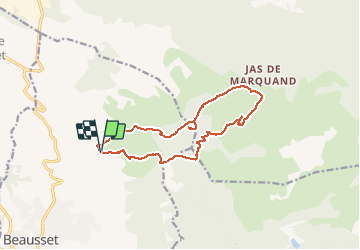

Length
14.4 km

Max alt
612 m

Uphill gradient
499 m
Km-Effort
21 km

Min alt
281 m

Downhill gradient
498 m
Boucle
Yes
Creation date :
2021-01-10 17:08:58.849
Updated on :
2021-01-10 17:17:40.18
4h24
Difficulty : Medium

FREE GPS app for hiking
 SityTrail
IGN / Geographical institutes
SityTrail Plus
The world is yours!
About
Trail Walking of 14.4 km to be discovered at Provence-Alpes-Côte d'Azur, Var, Le Beausset. This trail is proposed by soca.
Description
Le beausset - Abîme de Maramouyé - Les faïsses de Montrieux - La mare Caïre - La gueirarde - retour
Positioning
Country:
France
Region :
Provence-Alpes-Côte d'Azur
Department/Province :
Var
Municipality :
Le Beausset
Location:
Unknown
Start:(Dec)
Start:(UTM)
729706 ; 4789211 (31T) N.
Comments